| |
|
HomeRun
OSM tutorial
HomeRun Papers
Jörg Roth's Homepage
 email email
Impressum
Datenschutzerklärung
Privacy Policy
 This page
in German
|
| |
HomeRun is a platform for efficient development of location-based services, especially of small services.
HomeRun provides a set of basic services, e.g. import of geo data from public
sources. It contains an efficient communication infrastructure for service usage and offers
functional blocks for mobile devices, e.g. to display maps. As basic functions already exist, a service developer
can concentrate on the actual application. A development based on HomeRun is efficient and due to
the modularisation, can easily be modified later.
HomeRun has the following facets:


|
Mastering Geodata
|

|
Spatial Indexing
- Geospational Add-on (GAO) [1][2]
- Double Bounding Boxes (DBB) [7][8]
- Low-memory spatial indexing [23]
|

|
Spatial Services and Algorithms
|

|
Mobile Platforms
- Context-aware apps [9][10]
- Extracing geo data to mobile devices [5]
- Migrate services to mobile devices
|

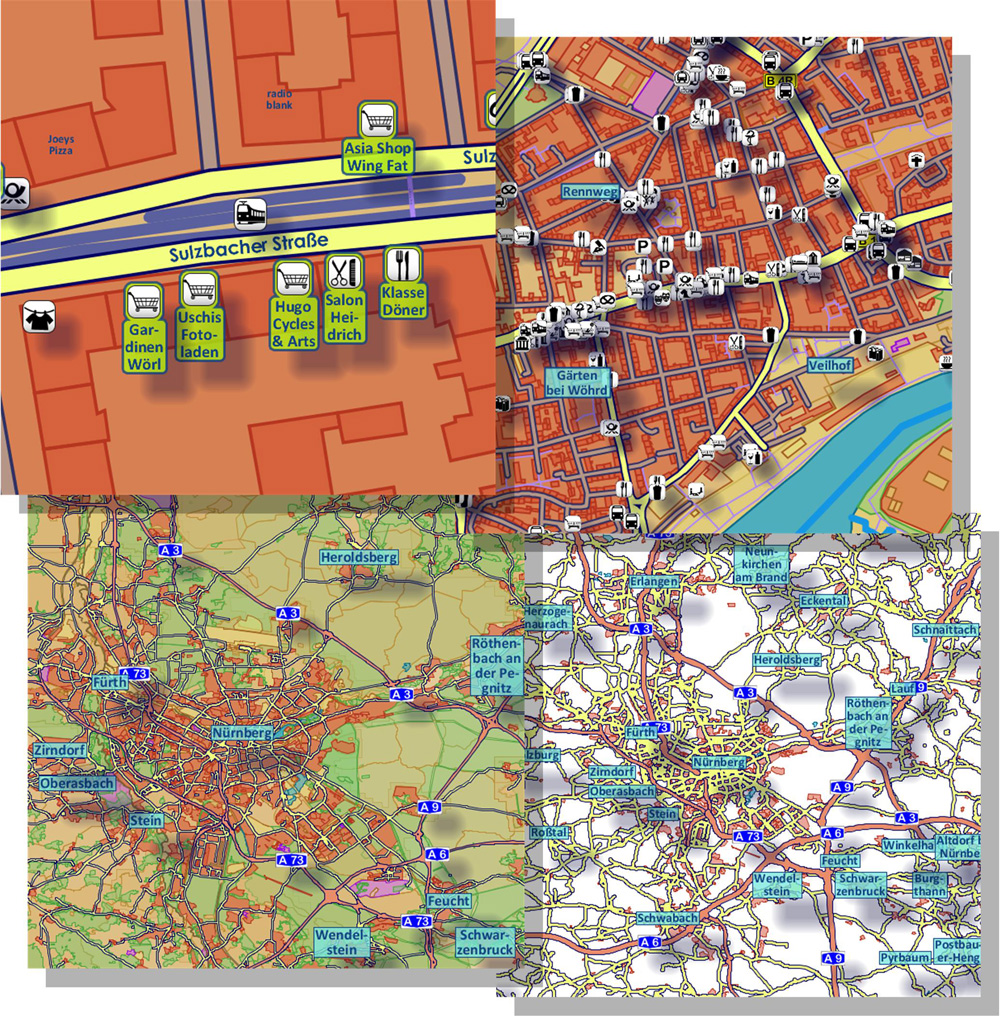
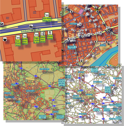
The dorenda platform provides a generation of map tiles
for map services and location-based applications.
The features:
- Rendering with different zoom levels and orientations
- Large rule set to control rendering:
- what will be displayed on each zoom level
- with or without an icon, which icon
- with or without a caption, which font size
- color of areas or lines, which line properties
- Configuring color themes, icon sets, font styles
- Generation of large map tile directories in batch mode
- Map tile server that can be access via web service interface
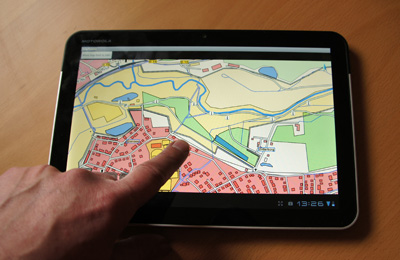
- Map client for desktop environments and Android
|
|

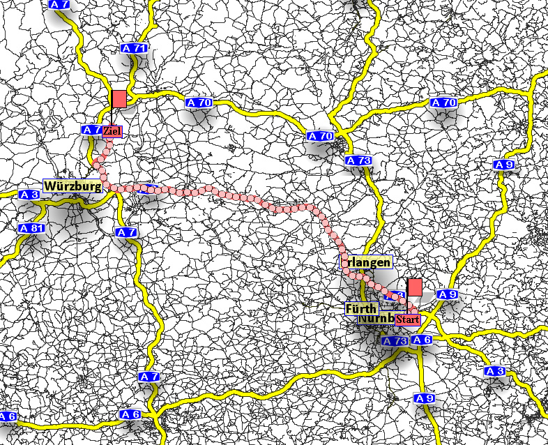
donavio is a complete environment for navigation. It can be used in server mode or offline.
It contains tools to generate topologies, to store and retrieve them efficiently and to compute shortest paths in street networks.
The features:
- Retrieve the street topology from OpenStreetMap sources
- Extracting properties that are relevant for routing, e.g. road type, speed limit, one-way road directions
- Efficient topology storage, optimized for routing
- Selectable routing profiles, e.g. car, pedestrian
- The path finding algorithm can be configured using heuristics, e.g.
- A* exact with line-of-sight estimation
- using overdo estimation
- using pre-computed ALT potentials (better estimation)
- ignoring small roads in the middle of a road (faster but sub-optimal)
- Configuring runtime behaviour: optimizing speed vs. optimizing memory usage
- With a special cache mechanism, the street topology may remain on an external storage and does not have to completely be loaded into runtime memory. With this, donavio can even run on small devices, e.g. smart phones.
- Routing server that can be access via web service interface
- Stand-alone routing application (offline) for desktop environments and Android
|
|
|
| [24] |
Jörg Roth:
Automatic Generation of Meaningful Virtual Direction Markers in Road Networks
in Frank Fuchs-Kittowski, Jörg Roth, Proceedings of the 14th Workshop on "Location-based applications and services", Sept. 21-22, 2017, Berlin, CEUR-WS, Vol-2020, ISSN 1613-0073
|

|
|
| [23] |
Jörg Roth:
Low-Memory Spatial Indexing
in Lars Fischer, Jörg Roth (eds.): 12. GI/ITG KuVS Fachgespräch "Ortsbezogene Anwendungen und Dienste", Sept. 17-18 2015, University Siegen, Logos Verlag, 2017, ISBN 978-3-8325-4395-2, 7-16
|
|
|
| [22] |
Jörg Roth:
Extracting Wikipedia Data to Enrich Spatial Information
17th International Conference on Innovations for Community Services (I4CS), Darmstadt, Germany, June 26-28 2017, Springer CCIS 717, 3-17
Winner of the Best Paper Award
|
|
|
| [21] |
Jörg Roth:
Efficient Computation of Bypass Areas
Gartner, Huang (eds): Progress in Location-Based Services 2016, Proc. of the
13th International Conference on Location-Based Services, Vienna, Austria, Nov. 1416, 2016, Springer LNG&C, 193-210
|
|
| [20] |
Jörg Roth:
The Offline Map Matching Problem and its Efficient Solution
16th International Conference on Innovations for Community Services (I4CS), Vienna, Austria, June 27-29, 2016 Springer CCIS 648, 23-38
Winner of the Best Paper Award
|
|
| [19] |
Jörg Roth:
Efficient many-to-many path planning and the Traveling Salesman Problem on road networks
International Journal of Knowledge-based and Intelligent Engineering Systems 20 (2016), IOS Press, 135148
|
|
| [18] |
Jörg Roth:
Fast Spatio-Symbolic Searching in Huge Geo Databases
in Volkmar Schau, Gerald Eichler, Jörg Roth (eds.): 11. GI/ITG KuVS Fachgespräch "Ortsbezogene Anwendungen und Dienste", Sept. 18-19, 2014, Telekom Innovation Laboratories, Darmstadt, Germany, Logos Verlag, 2015, ISBN 978-3-8325-4135-4, 131-140
|
|
| [17] |
Jörg Roth:
Generating Meaningful Location Descriptions
International Conference on Innovations for Community Services (I4CS), July 8-10, 2015, Nuremberg (Germany), IEEE xplore, 30-37
|
|
| [16] |
Jörg Roth:
Predicting Route Targets Based on Optimality Considerations
International Conference on Innovations for Community Services (I4CS), Reims (France) June 4-6, 2014, IEEE xplore, 61-68
|
|
| [15] |
Jörg Roth:
From Weak to Strong Geo Object Classification
in Schau V., Eichler G., Roth J. (Hrsg.): 10. GI/ITG KuVS Fachgespräch "Ortsbezogene Anwendungen und Dienste", 16.-17. Sept. 2013, FSU Jena, Logos Verlag Berlin, 2014, ISBN 978-3-8324-3813-2, 3-12
|
|
| [14] |
Jörg Roth:
Combining Symbolic and Spatial Exploratory Search – the Homerun Explorer
Innovative Internet Computing Systems (I2CS), Hagen (Germany), June 19-21, 2013, Fortschritt-Berichte VDI, Reihe 10, Nr. 826, 94-108
Winner of the Best Paper Award
|
|
| [13] |
Jörg Roth:
A Spatial Hashtable Optimized for Mobile Storage on Smart Phones
in Werner M., Haustein M. (eds.): 9. GI/ITG KuVS Fachgespräch "Ortsbezogene Anwendungen und Dienste", 13.-14. Sept. 2012, TU Chemnitz, Universitätsverlag Chemnitz, 2013, ISBN 978-3-941003-77-4, 71-84
|
|
| [12] |
Jörg Roth:
Modularisierte Routenplanung mit der donavio-Umgebung
in Werner M., Haustein M. (eds.): 9. GI/ITG KuVS Fachgespräch "Ortsbezogene Anwendungen und Dienste", 13.-14. Sept. 2012, TU Chemnitz, Universitätsverlag Chemnitz, 2013, ISBN 978-3-941003-77-4, 119-131
|
|
| [11] |
Jörg Roth:
Sharing Personal Symbolic Locations between Friends – A Location Service for Small Communities
Innovative Internet Computing Systems (I2CS), Trondheim, Norway, June 13-15, 2012, GI Lecture Notes in Informatics, Vol. P-204, 17-27
|
|
| [10] |
Jörg Roth:
Developing a context-aware calendar app using a mobile context platform
in Werner M., Roth J. (eds.): 8. GI/ITG KuVS Fachgespräch "Ortsbezogene Anwendungen und Dienste", Logos-Verlag, 2011, ISBN 987-3-8325-3041-9, 11-22
|
|
| [9] |
Jörg Roth:
Context-aware Apps with the Zonezz Platform
ACM MobiHeld 2011, Proceedings of the 3rd ACM SOSP Workshop on Networking, Systems, and Applications on Mobile Handhelds, Cascais (Portugal), Oct. 23, 2011
|
|
| [8] |
Jörg Roth:
The Approximation of Two-Dimensional Spatial Objects by Two Bounding Rectangles
Spatial Cognition & Computation: An Interdisciplinary Journal,
Volume 11, Issue 2, 2011, ISSN 1387-5868, 129-152
|
|
| [7] |
Jörg Roth:
An O(n) approximation for the double bounding box problem
IADIS International Conference Informatics 2011, Rome (Italy), July 20-22, 2011, 27-34
|
|
| [6] |
Jörg Roth:
Der Einsatz von OpenStreetMap-Daten in der akademischen Informatik-Ausbildung
in Käpper A., Roth J. (Hrsg.): 7. GI/ITG KuVS Fachgespräch "Ortsbezogene Anwendungen und Dienste", Logos-Verlag, 2011, ISBN 987-3-8325-2935-2, 65-72
|
|
| [5] |
Jörg Roth:
Moving Geo Databases to Smart Phones An Approach for Offline Location-based Applications
Innovative Internet Computing Systems (I2CS), Berlin (Germany), June 15-17, 2011, GI Lecture Notes in Informatics, Vol. P-186, 228-238
|
|
| [4] |
Jörg Roth:
Übernahme von Geodatenbeständen aus Open Street Map und Bereitstellung einer effizienten Zugriffsmöglichkeit für ortsbezogene Dienste
Praxis der Informationsverarbeitung und Kommunikation (PIK), Vol. 13, No. 4, 2010, 268-277, ISSN 0930-5157
|
|
| [3] |
Jörg Roth:
Die HomeRun-Plattform für ortsbezogene Dienste außerhalb des Massenmarktes
in Zipf A., Lanig S., Bauer M. (Hrsg.) 6. GI/ITG KuVS Fachgespräch "Ortsbezogene Anwendungen und Dienste", Heidelberger Geographische Bausteine Heft 18, 2010, ISBN 987-3-88570-818-6, 1-9
|
|
| [2] |
Jörg Roth:
The Extended Split Index to Efficiently Store and Retrieve Spatial Data With Standard Databases
IADIS International Conference Applied Computing 2009, Rome (Italy), Nov. 19-21, 2009, Vol. I, ISBN 978-972-8924-97-3, 85-92
|
|
| [1] |
Jörg Roth:
Verwaltung geographischer Daten mit Hilfe eines Add-ons für Standard-Datenbanken
Verwaltung, Analyse und Bereitstellung kontextbasierter Informationen, GI Informatik 2009, Lübeck (Germany), Sept. 29, 2009, 2041-2055
|
|
|
|